
The Pioneer-Sarah Creek Watershed Management Commission is the regional governmental unit responsible for protecting the water resources of the Pioneer-Sarah Creek watershed, located in western Hennepin County, Minnesota.
The Commission adopted our Fourth Generation Watershed Management Plan to provide direction and inform decisions for the 10-year period of 2021-2030 on December 17. 2020.
|
Commission Meets Monthly
The Pioneer-Sarah Creek Watershed Management Commission meetings are held at 6:00 p.m. on the third Thursday of each month at Maple Plain City Hall, 5050 Independence Street, Maple Plain, MN. For meeting information, click here. |
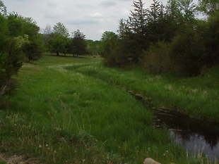
Lake Independence - Baker Park Ravine Restoration
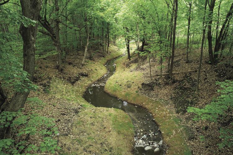
A $520,000 fix of this giant ravine in Baker Park has transformed a sediment laden channel into a haven for spring wildflowers.
This project will reduce phosphorus flow into the lake which results in pea-green algae blooms.
(Photo courtesy of Minnesota Board of Water and Soil Resources)
A project completed in spring 2020 in Three Rivers Park District’s Baker Park Reserve is designed to improve the water quality of Lake Independence. One of Hennepin County’s most heavily used lakes, it is impaired for excessive nutrients.
A 2014 subwatershed analysis identified channel erosion in a ravine leading to the lake as a top sediment and phosphorus contributor. It carried an estimated 277 pounds of phosphorus and 300 tons of sediment — the equivalent of 23 dump truck loads — to Lake Independence annually. Phosphorus feeds the algae that can turn lakes green. The estimated pollutant removal of the
project is 134 pounds of phosphorous annually.
The $520,000 Pioneer-Sarah Creek Watershed Management Commission ravine stabilization, which came in $34,000 under budget, will accomplish an estimated 15% of the phosphorus reduction needed to meet Minnesota Pollution Control Agency water-quality standards. Work was made possible by a $416,000 Clean Water Fund grant from the Minnesota Board of Water and Soil Resources. A $59,500 Hennepin County Opportunity Grant from the county’s Environment and Energy Department, plus $44,500 cost-share among the WMC, park district, Lake Independence Citizens Association and the cities of Independence and Medina covered the balance.
“Clean Water Funds by all means enable a project like this,” Baker said “The cities of Independence, Medina and a small part of Maple Plain as the cities of benefit just really would not have the funds for that. We’ve had great support from BWSR as well as Hennepin County and Three Rivers Park District to ultimately pull the funding together.” The Minnesota Board of Water and Soil Resources’ mission is to improve and protect Minnesota’s water and soil resources by working in partnership with local organizations and private landowners.
Despite the algae, 832-acre Lake Independence remains a primary attraction in the metro park that saw well over a half-million visitors in 2018. The WMC deemed Lake Independence a high-priority sentinel lake, based partly on its high visibility and recreational use for swimming, boating and fishing. Lake Independence attracted more than 27,100 swimmers to the park’s two beaches, launched nearly 15,600 boaters from its public access and drew more than 3,400 anglers to its shore in 2018, the most recent year for which Metropolitan Council data are available. A community of fish houses pops up during the winter. Anglers target crappies in early spring, walleye in the summer, and muskies well into the fall.
“The reduction of phosphorus in Lake Independence will clearly lead towards improved water quality and most notably water clarity,” said Joe Baker, chairman of the Pioneer-Sarah Creek WMC. The stabilization is a first step to reduce external phosphorus loading. To accomplish its long-term goal of increasing the lake’s clarity to 8 to 12 feet.

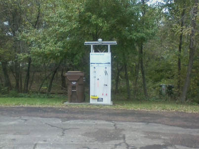
The Lake Sarah CD3 Outpost was installed yesterday! The City and the Lake Association will be given access to view the use data. Last night, I was heading to the dog park around 6:30pm. There was a fishing boat parked right at the CD3 station. I told him he may be the first ever user. He mentioned that he has seen these units at Long Lake and really like the grabber tool to get the weeds from under the boat. Fun to see it used already! Also, a reminder to me on how much the boating community moves around from lake to lake looking for those big pan fish! https://youtu.be/IV3Y4AV4zzA |
|
|
Notice of Availability and Request for Comment on Draft Pioneer-Sarah Creek Watershed Restoration and Protection Strategies (WRAPS) and Total Maximum Daily Load (TMDL) Reports is open for formal public comment through May 31, 2017. For more information, visit the MPCA Public Notices webpage. |
Dance Hall Creek Subwatershed Assessment
Lake Sarah is a highly utilized and valued public resource in the Pioneer-Sarah creek Watershed. In 2011 the Pioneer Sarah Creek Watershed Management Commission, in partnership with the Minnesota Pollution Control Agency (MPCA) and Three Rivers Park District (TRPD), completed a Total Maximum Daily Load (TMDL) analysis to quantify the phosphorus reductions needed to meet state water quality standards for nutrients in Lake Sarah in accordance with the Clean Water Act. The study identified the Dance Hall Creek watershed as a "hot-spot" for contributing nutrients to Sarah Lake. Dance Hall Creek drains to Sarah Lake which drains via Sarah Creek to the Crow River. In 2013 the Hennepin County Environmental Services Department (HCES) performed a stormwater retro-fit study for the Dance Hall Creek watershed within the City of Greenfield. The study was a partnership between the HCD, HCES, City of Greenfield, and Crow River Watershed Association. Data from the study will be utilized by the partners to seek Clean Water Legacy BMP funds.
Lake Sarah is a highly utilized and valued public resource in the Pioneer-Sarah creek Watershed. In 2011 the Pioneer Sarah Creek Watershed Management Commission, in partnership with the Minnesota Pollution Control Agency (MPCA) and Three Rivers Park District (TRPD), completed a Total Maximum Daily Load (TMDL) analysis to quantify the phosphorus reductions needed to meet state water quality standards for nutrients in Lake Sarah in accordance with the Clean Water Act. The study identified the Dance Hall Creek watershed as a "hot-spot" for contributing nutrients to Sarah Lake. Dance Hall Creek drains to Sarah Lake which drains via Sarah Creek to the Crow River. In 2013 the Hennepin County Environmental Services Department (HCES) performed a stormwater retro-fit study for the Dance Hall Creek watershed within the City of Greenfield. The study was a partnership between the HCD, HCES, City of Greenfield, and Crow River Watershed Association. Data from the study will be utilized by the partners to seek Clean Water Legacy BMP funds.
Ardmore Area Subwatershed Stormwater Retrofit Assessment
This report details urban and rural stormwater assessment studies and Best Management Practices (BMPs) recommendations within the City of Medina to reduce phosphorus loads flowing into Lake Independence and Lake Ardmore. Since different types of BMPs must be utilized in order to be effective for the urban and rural portions of the watershed, the report is organized in two sections. The first section analyzes the residential urban area that it situated between Lake Independence and Lake Ardmore and drains to both basins. The second section analyzes the rural subwatershed that drains to Lake Ardmore and ultimately to Lake Independence.
The rural portion of this assessment is approximately 472 acres in size – 423 in the city of Medina and 49 in the City of Independence. The developed community studied for this assessment is 113 acres and located in Medina between Lake Independence and Lake Ardmore. The purpose of the Ardmore Area Subwatershed Assessment is to assist the City of Medina in its decisions and processes to provide cost effective methods to help reduce phosphorus loads into Lake Ardmore and Lake Independence from these two subwatersheds.
CONTACT US
Pioneer-Sarah Watershed Management Commission
3235 Fernbrook Lane N, Plymouth, MN 55447
Phone (763) 553-1144 Fax (763) 553-9326
Email [email protected]
Pioneer-Sarah Watershed Management Commission
3235 Fernbrook Lane N, Plymouth, MN 55447
Phone (763) 553-1144 Fax (763) 553-9326
Email [email protected]